Route, GPS, Maps, Elevation Profile
The route of the Jókai Ultramarathon:
Camping Făget (START) – Bükk (Făget) forest – Adrenalin Park (CP 1) – Fountain with Barrel (CP 2) – Túri-hasadék (CP 3) – Szind (Săndulești) (CP 4) – Turda Gorge (CP 5) – Monastery Heights (CP 6) – Curmătura (CP 7) – Várfalva (Moldovenești) (CP 8) – Székelykő (Szekler Stone, Piatra Secuiului) (CP 9) – Torockó (Rimetea) (FINISH).
The length of the course is 59.60 km, the target time set by the organizers for the completion of the marathon is 10 hours.
Total ascent: 1992 m, total descent: 2071 m.
The route is presented in detail with descriptions, printed and digital maps, as well as GPS track. We will renew the painted tourist markings and will place sign-boards and ribbons to mark the routes.
If for some reason you cannot or do not want to continue the marathon, we recommend the following places (easily accessible by car) to drop out: Adrenalin Park, Tordatúr (Tureni), Szind (Sandulesti), Turda Gorge, Várfalva (Moldovenesti).
In exceptional cases (e.g. extreme weather conditions) the organizers reserve the right to change the marathon course or to cancel the whole race or certain stages of it.
The actualized route can be downloaded in gpx format from here and the actualized map in pdf from here.
The tour route can be downloaded in various formats from here:
Outdoor Maps Romania app and map
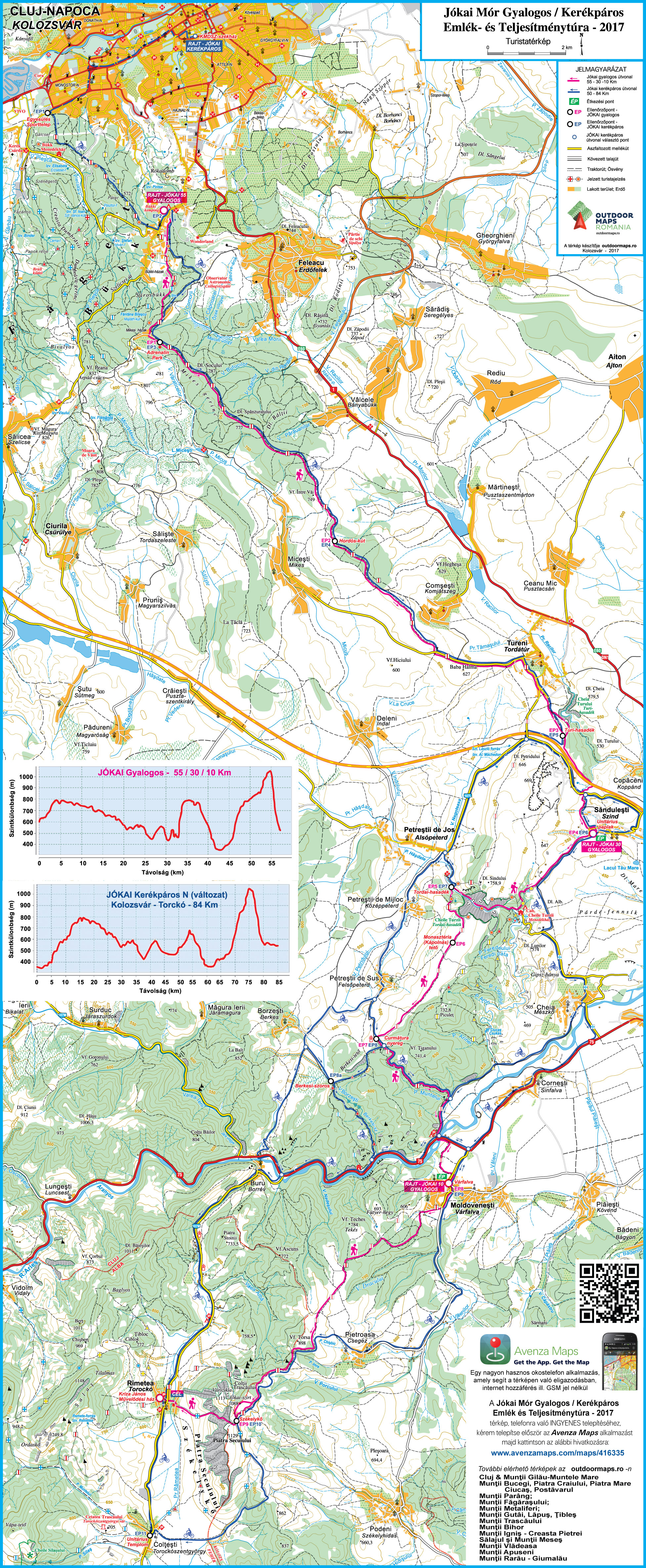 EKE – Kolozsvár 1891 and Outdoor Maps Romania offer the participants of the Mór Jókai Ultramarathon a free smartphone app, which, together with the detailed map, helps in the navigation.
It does not require an internet connection or GSM network, using only GPS, you can be certain at any point of the marathon that you are on the right track.
Download and install the Avenzamaps app (Google Play, AppStore) from here:
www.avenzamaps.com/maps/how-it-works.html
and then the map from the following link:
www.avenzamaps.com/maps/416335
If you have problems with the installation or need advice, please call +4 0745 532206.
Other recommended maps
Beside the maps and directions provided by the organizers, we recommend the following printed maps, containing detailed information on certain sections of the Jókai ultramarathon.