Route, GPS, Maps, Elevation Profile Bicycle Tours 2021
The total length of the course is about 63-89 km, depending on the route chosen on the Szind-Torockó section.
The target time set by the organizers for the completion of the tour is 10 hours, but we estimate that it can be completed in as little as 8 hours, even the more difficult versions.
Total ascent: 1275–2296 m, total descent: 1078-2104 m, depending on the chosen route.
The route is presented in detail with descriptions (Tour Guide), printed and digital maps, as well as GPS track. We will renew the painted tourist markings and will place sign-boards and ribbons to mark certain sections of the routes. Special sign-boards will be placed at every road junction with several route options.
Tour difficulty: medium to difficult. Off-road biking experience is required, the more difficult options are recommended only for experienced and fit participants.
If for some reason you cannot or do not want to continue the tour, we recommend the following places (easily accessible by car) to drop out: Camping Făget, Tordatúr (Tureni), Szind (Sănduleşti), Várfalva (Moldoveneşti).
In exceptional cases (e.g. extreme weather conditions) the organizers reserve the right to change the tour course or to cancel the whole tour or certain stages of it.
Section Kolozsvár–Szind
Section Kolozsvár–Szind (37.52 km): Kolozsvár (Cluj), EKE – Kolozsvár 1891 office (START) – Mănăştur, Unirea Sports Park (CP 1) – Camping Făget (CP 2) – Bükk (Făget) forest – Adrenalin Park (CP 3) – Fountain with Barrel (CP 4) – Tureni Gorge (CP 5) – Szind (Sănduleşti), Unitarian parsonage (CP 6).
Total length: 37.52 km | Total ascent: 865 m | Total descent: 739 m
| Route section | Length (km) | Total ascent (m) |
Total descent (m) |
Checkpoints (CP) and measurement points (MP) on the route section |
|---|---|---|---|---|
| EKE – Kolozsvár 1891 office – Unirea Sports Park | 5.98 | 113 | 41 | EKE – Kolozsvár 1891 office (START) – Unirea Sports Park (CP 1) |
| Unirea Sports Park – Camping Făget | 5.16 | 237 | 39 | Unirea Sports Park (1. EP) MP-01 MP-02 MP-03 MP-04 MP-05 Camping Făget (2. EP) Alternative route: [Unirea Sports Park MP-04] |
| Camping Făget – Adrenalin Park | 4.78 | 219 | 42 | Camping Făget (CP 2) MP-06 MP-07 MP-08 MP-09 MP-10 MP-11 MP-12 MP-15 MP-16 MP-17 Adrenalin Park (CP 3) Alternative route: [MP-12 MP-16] |
| Adrenalin Park – Fountain with Barrel | 6.96 | 91 | 136 | Adrenalin Park (CP 3) MP-18 MP-19 MP-20 MP-21 MP-22 Fountain with Barrel (CP 4) |
| Fountain with Barrel – Tureni Gorge | 9.79 | 146 | 305 | Fountain with Barrel (CP 4) MP-23 MP-24 MP-25 MP-26 MP-27 MP-28 MP-29 MP-30 MP-31 Tureni Gorge (CP 5) |
| Tureni Gorge – Szind (Sănduleşti) | 4,85 | 53 | 171 | Tureni Gorge (CP 5) MP-32 MP-33 MP-36 MP-37 MP-38 MP-39 Szind (Sănduleşti) (CP 6) |

Route options for the section Szind (Sănduleşti) – Torockó (Rimetea)
Section Szind-Torockó (25.22–51.77 km): starting from Szind (Sănduleşti), the participants can choose one of 19 route variations to arrive to Torockó (Rimetea), passing through some of the following checkpoints, according to their route choice: Turda Gorge (CP 7), Curmătura (CP 8), Borzești Gorge (CP 8a ), Várfalva (Moldoveneşti, EKE House – CP 9), Székelykő (Szekler Stone, Piatra Secuiului – CP 10), Torockó (Rimetea, János Kriza Community Centre – FINISH).
The detailed description of the route variations can be downloaded here  .
.
The map and track (in various formats) of the individual route variations can be downloaded from the appropriate rows of the following table:
| No. | Route | Difficulty | Length | Description | Map | Track |
|---|---|---|---|---|---|---|
| 1 | A | easy | 34.00 km | Szind (Sănduleşti, CP) – Turda Gorge (CP) – Borzești Gorge (CP) – Borrév (Buru) – Torockó (Rimetea, FINISH) |  |
 |
| 2 | B | easy | 31.58 km | Szind (Sănduleşti, CP) – Turda Gorge (CP) – Borrév (Buru) – Torockó (Rimetea, FINISH) | |
|
| 3 | K | easy | 30.76 km | Szind (Sănduleşti, CP) – Várfalva (Moldoveneşti, CP) – Borrév (Buru) – Torockó (Rimetea, FINISH) | |
|
| 4 | M | easy | 25.22 km | Szind (Sănduleşti, CP) – Mészkő (Cheia) – Aranyos (Arieș) Valley – Borrév (Buru) – Torockó (Rimetea, FINISH) | |
|
| 5 | I | medium | 42.69 km | Szind (Sănduleşti, CP) – Curmătura (CP) – Borzești Gorge (CP) – Várfalva (Moldoveneşti, CP) – Borrév (Buru) – Torockó (Rimetea, FINISH) | |
|
| 6 | D | medium | 40.63 km | Szind (Sănduleşti, CP) – Turda Gorge (CP) – Curmătura (CP) – Várfalva (Moldoveneşti, CP) – Borrév (Buru) – Torockó (Rimetea, FINISH) | |
|
| 7 | C | medium | 36.48 km | Szind (Sănduleşti, CP) – Turda Gorge (CP) – Curmătura (CP) – Borzești Gorge (CP) – Borrév (Buru) – Torockó (Rimetea, FINISH) | |
|
| 8 | F | medium | 35.09 km | Szind (Sănduleşti, CP) – Turda Gorge (CP) – Curmătura (CP) – Aranyos (Arieș) Valley – Borrév (Buru) – Torockó (Rimetea, FINISH) | |
|
| 9 | H | medium | 33.04 km | Szind (Sănduleşti, CP) – Curmătura (CP) – Borzești Gorge (CP) – Borrév (Buru) – Torockó (Rimetea, FINISH) | |
|
| 10 | G | medium | 30.62 km | Szind (Sănduleşti, CP) – Curmătura (CP) – Borrév (Buru) – Torockó (Rimetea, FINISH) | |
|
| 11 | N | difficult | 51.42 km | Szind (Sănduleşti, CP) – Turda Gorge (CP) – Curmătura (CP) – Borzești Gorge (CP) – Várfalva (Moldoveneşti, CP) – Szekler Stone (CP) – Torockószentgyörgy (Colţeşti) – Torockó (Rimetea, FINISH) | |
|
| 12 | J | difficult | 47.98 km | Szind (Sănduleşti, CP) – Curmătura (CP) – Borzești Gorge (CP) – Várfalva (Moldoveneşti, CP) – Szekler Stone (CP) – Torockószentgyörgy (Colţeşti) – Torockó (Rimetea, FINISH) | |
|
| 13 | E | difficult | 45.92 km | Szind (Sănduleşti, CP) – Turda Gorge (CP) – Curmătura (CP) – Várfalva (Moldoveneşti, CP) – Szekler Stone (CP) – Torockószentgyörgy (Colţeşti) – Torockó (Rimetea, FINISH) | |
|
| 14 | L | difficult | 36.04 km | Szind (Sănduleşti, CP) – Várfalva (Moldoveneşti, CP) – Szekler Stone (CP) – Torockószentgyörgy (Colţeşti) – Torockó (Rimetea, FINISH) | |
|
Detailed data of the route sections between Szind (Sănduleşti) and Torockó (Rimetea)
The detailed data of the route sections between Szind (Sănduleşti) and Torockó (Rimetea) are comprised in the following table:
| Route section | Length (km) | Total ascent (m) | Total descent (m) | Checkpoints (CP) and measurement points (MP) on the route section |
Route variations containing the section |
|---|---|---|---|---|---|
| Szind (Sănduleşti) – Magyarpeterd (Petreștii de Jos) – Turda Gorge | 10.55 | 200 | 198 | Szind (Sănduleşti) (CP 6) MP-39 MP-36b MP-33 MP-42 Turda Gorge (CP 7) | A, B, C, D, E, F, N |
| Szind (Sănduleşti) – Mészkő (Cheia) – Várfalva (Moldoveneşti) | 14.77 | 228 | 297 | Szind (Sănduleşti) (CP 6) MP-40 MP-49 MP-50 MP-51 MP-57 MP-58 MP-59 Várfalva (Moldoveneşti) (CP 9) | K, L |
| Szind (Săndulești) – Mészkő (Cheia) – Torockó (Rimetea) | 25.22 | 410 | 339 | Szind (Sănduleşti) (CP 6) MP-40 MP-49 MP-50 MP-51 MP-57 MP-56 MP-80 Torockó (Rimetea) (FINISH) | M |
| Szind (Sănduleşti) – Mészkő (Cheia) – Curmătura | 14.13 | 493 | 274 | Szind (Sănduleşti) (CP 6) MP-40 MP-49 MP-50 MP-51 MP-48 Curmătura (CP 8) | G, H, I, J |
| Turda Gorge – Curmătura | 7.02 | 241 | 21 | Turda Gorge (CP 7) MP-42 MP-43 MP-47 Curmătura (CP 8) | C, D, E, F, N |
| Turda Gorge – Borzești Gorge | 9.41 | 193 | 103 | Turda Gorge (CP 7) MP-42 MP-43 MP-47 MP-53 Borzești Gorge (CP 8a) ) | A |
| Turda Gorge – Borrév (Buru) – Torockó (Rimetea) | 21.03 | 435 | 366 | Turda Gorge (CP 7) MP-42 MP-43 MP-47 MP-53 MP-79 MP-80 Torockó (Rimetea) (FINISH) | B |
| Curmătura – Borzești Gorge | 4.87 | 50 | 179 | Curmătura (CP 8) MP-47 MP-53 Borzești Gorge (CP 8a ) | C, H, I, J, N |
| Curmătura – Várfalva (Moldoveneşti) | 7.07 | 76 | 365 | Curmătura (CP 8) MP-48 MP-51 MP-57 MP-58 MP-59 Várfalva (Moldoveneşti) (CP 9) | D, E |
| Curmătura – Aranyos (Arieş) Valley – Torockó (Rimetea) | 17.52 | 257 | 406 | Curmătura (CP 8) MP-48 MP-51 MP-57 MP-56 MP-80 Torockó (Rimetea) (FINISH) | F |
| Curmătura – Borrév (Buru) – Torockó (Rimetea) | 16.49 | 293 | 4412 | Curmătura (CP 8) MP-47 MP-53 MP-79 MP-80 Torockó (Rimetea) (FINISH) | G |
| Borzești Gorge – Várfalva (Moldoveneşti) | 7.70 | 94 | 254 | Borzești Gorge (CP 8a ) MP-56 MP-57 MP-58 MP-59 Várfalva (Moldoveneşti) (CP 9) | I, J, N |
| Borzești Gorge – Torockó (Rimetea) | 14.04 | 250 | 270 | Borzești Gorge (CP 8a ) MP-56 MP-80 Torockó (Rimetea) (FINISH) | A, C, H |
| Várfalva (Moldoveneşti) – Borrév (Buru) – Torockó (Rimetea) | 15.99 | 244 | 104 | Várfalva (Moldoveneşti) (CP 9) MP-59 MP-58 MP-57 MP-56 MP-80 Torockó (Rimetea) (FINISH) | D, I, K |
| Várfalva (Moldoveneşti) – Szekler Stone | 11.94 | 744 | 83 | Várfalva (Moldoveneşti) (CP 9) MP-60 MP-63 MP-64 MP-65 MP-68 MP-70 MP-71 MP-72 Székelykő (Szekler Stone) (CP 10) | E, J, L, N |
| Alternative routes: [MP-63 MP-66 MP-67 MP-68] [MP-68 MP-69 MP-70] |
|||||
| Szekler Stone – Torockószentgyörgy (Colţeşti) – Torockó (Rimetea) | 9.34 | 46 | 577 | Székelykő (Szekler Stone) (CP 10) MP-73 MP-74 MP-75 MP-76 MP-77 MP-78 Torockó (Rimetea) (FINISH) |
The detailed data of the route sections between Szind (Sănduleşti) and Torockó (Rimetea) can be downloaded here .
Outdoor Maps Romania app and map
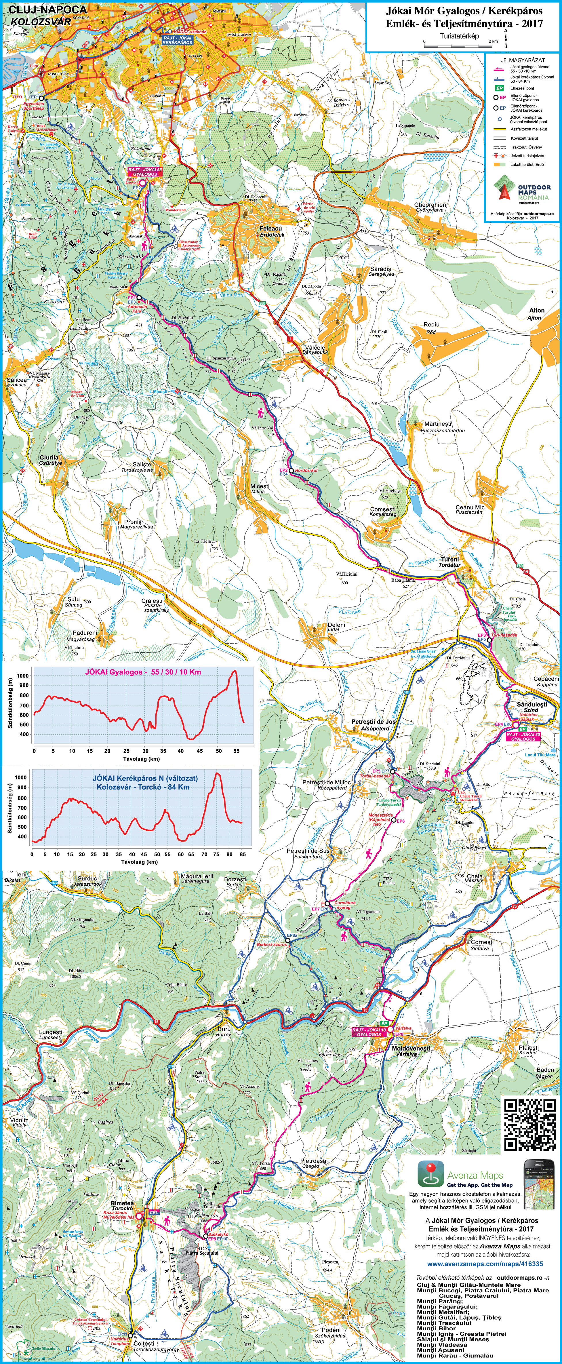 EKE – Kolozsvár 1891 and Outdoor Maps Romania offer the participants of the Mór Jókai Memorial Endurance Tours a free smartphone app, which, together with the detailed tour map, helps in the navigation.
It does not require an internet connection or GSM network, using only GPS, you can be certain at any point of the tour that you are on the right track.
Download and install the Avenzamaps app (Google Play, AppStore) from here:
www.avenzamaps.com/maps/how-it-works.html
and then the map from the following link:
www.avenzamaps.com/maps/416335
If you have problems with the installation or need advice, please call +4 0745 532206.
Other recommended maps
Beside the maps and directions provided by the organizers, we recommend the following printed maps, containing detailed information on certain sections of the Jókai endurance tour.