Route, GPS, Maps, Elevation Profile Hiking 2022
Gy52 hiking tour
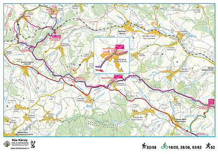
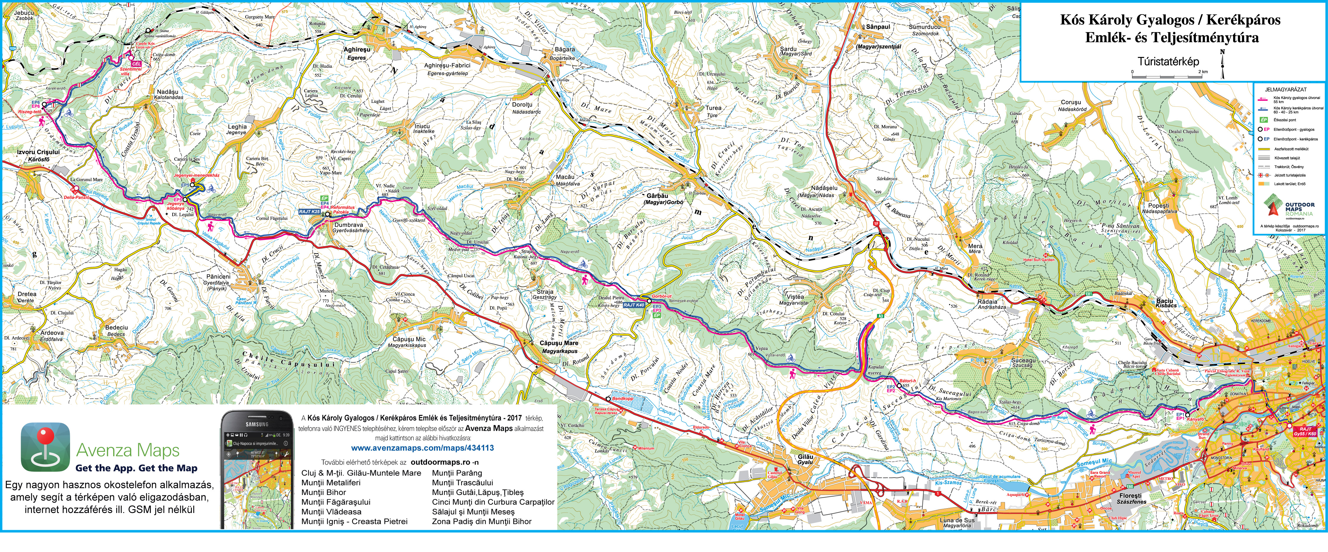
Route: Cluj (Kolozsvár), Rooster Church (START) – Hoia forest – Hoia hill (Kányafő, CP 1) – Snail hill (Florești) – Suceagului hill (Kis-Martonos tető) – Bátori hill (Bátori-hegy, CP 2) – Kapulat saddle – A3 motorway – Gârbău road (CP 3) – Bear hill (Medvepad) – Gyerőfi rock – Dumbrava (Gyerővásárhely), Reformed Church parsonage (CP 4) – Leghia (Jegenye) road (CP 5) – Ordományos hill – Riseg hill (CP 6) – Stana (Sztána), Szentimrei Villa (FINISH).
The length of the course is 51,99 km, the target time set by the organizers for the completion of the tour is 12 hours
Total ascent: 1536 m, total descent: 1346 m.
Difficulty: high.
Gy58 hiking tour (extended version of Gy52)
Route: Cluj (Kolozsvár), Rooster Church (START) – Hoia forest – Hoia hill (Kányafő, CP 1) – Snail hill (Florești) – Suceagului hill (Kis-Martonos tető) – Bátori hill (Bátori-hegy, CP 2) – Kapulat saddle – A3 motorway – Gârbău road (CP 3) – Bear hill (Medvepad) – Gyerőfi rock – Dumbrava (Gyerővásárhely), Reformed Church parsonage (CP 4) – Leghia (Jegenye) road (CP 5) – Ordományos hill – Riseg hill (CP 6) – Jebucu (Zsobok), Reformed Church (CP 7) – Stana (Sztána), Szentimrei Villa (FINISH).
The length of the course is 57,76 km, the target time set by the organizers for the completion of the tour is 12 hours
Total ascent: 1704 m, total descent: 1515 m.
Difficulty: high.
Gy27 hiking tour
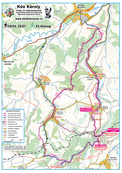
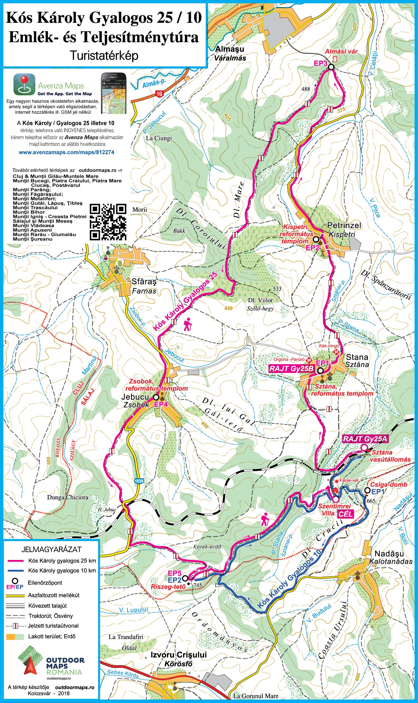
Route: Stana (Sztána), railway station (START) – Stana (Sztána), Reformed Church (CP 1) – Petrinzel (Kispetri), Reformed Church (CP 2) – Almaş fortress (CP 3) – Jebucu (Zsobok), Reformed Church (CP 4) – Riseg hill (CP 5) – Stana (Sztána), Szentimrei Villa (FINISH)
The length of the course is 26,64 km, the target time set by the organizers for the completion of the tour is 7 hours
Total ascent: 816 m, total descent: 803 m.
Difficulty: medium.
Gy22 hiking tour (shortened version of Gy27)
Route: Stana (Sztána), railway station (START) – Stana (Sztána), Reformed Church (CP 1) – Petrinzel (Kispetri), Reformed Church (CP 2) – Almaş fortress (CP 3) – Jebucu (Zsobok), Reformed Church (CP 4) – Stana (Sztána), Szentimrei Villa (FINISH)
The length of the course is 21,83 km, the target time set by the organizers for the completion of the tour is 6 hours
Total ascent: 617 m, total descent: 605 m.
Difficulty: medium.
Gy24 hiking tour
Route: Stana (Sztána), Reformed Church (START) – Petrinzel (Kispetri), Reformed Church (CP 2) – Almaş fortress (CP 3) – Jebucu (Zsobok), Reformed Church (CP 4) – Riseg hill (CP 5) – Stana (Sztána), Szentimrei Villa (FINISH)
The length of the course is 23,75 km, the target time set by the organizers for the completion of the tour is 7 hours
Total ascent: 778 m, total descent: 699 m.
Difficulty: medium.
Gy19 hiking tour (shortened version of Gy24)
Route: Stana (Sztána), Reformed Church (START) – Petrinzel (Kispetri), Reformed Church (CP 2) – Almaş fortress (CP 3) – Jebucu (Zsobok), Reformed Church (CP 4) – Stana (Sztána), Szentimrei Villa (FINISH)
The length of the course is 18,94 km, the target time set by the organizers for the completion of the tour is 6 hours
Total ascent: 579 m, total descent: 501 m.
Difficulty: medium.
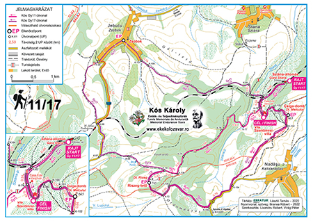
Gy11 hiking tour
Route: Stana (Sztána), railway station (START) – Snail hill (CP 1) – Riseg hill (CP 2) – Stana (Sztána), Szentimrei Villa (FINISH)
The length of the course is 10,66 km, the target time set by the organizers for the completion of the tour is 5 hours
Total ascent: 406 m, total descent: 392 m.
Difficulty: low.
Gy17 hiking tour (extended version of Gy11)
Route: Stana (Sztána), railway station (START) – Snail hill (CP 1) – Riseg hill (CP 2) – Jebucu (Zsobok), Reformed Church (CP 3) – Stana (Sztána), Szentimrei Villa (FINISH)
The length of the course is 16,43 km, the target time set by the organizers for the completion of the tour is 6 hours
Total ascent: 574 m, total descent: 561 m.
Difficulty: low.
Additional distance to cover after the tour: Szentimrei Villa – Stana (Sztána) railway station (1.08 km), respectively Szentimrei Villa – Stana (Sztána) village (2.67 km).
For Gy52/58 participants who for some reason cannot or do not want to continue the tour, we recommend the following places (accessible by car) to drop out: Kapulat saddle, Gârbău road (CP 3), Straja (Gesztrágy) (K-43), Dumbrava (Gyerővásárhely) (CP 4), Leghia (Jegenye) road (DJ 108C), Nadășu (Kalotanádas) road (DC 135), Riseg hill (from here you can quickly descend to Izvoru Crișului (Körösfő)).
Participants of the Gy19/24, Gy22/27 and Gy11/17 tours who for some reason cannot or do not want to continue the tour, notify the organizers or the checkpoint stewards (if needed, any checkpoint can be reached by car).
Tour maps (in Hungarian or Romanian) / Elevation profiles
Gy11/17
Gy19/24, Gy22/27, K33-Alszeg
Gy52/58, K16/25, K28/36, K53/62
GPS tracks
Hiking 58 – the track can be downloaded in gpx format from here
Hiking 52 – the track can be downloaded in gpx format from here
Hiking 27 – the track can be downloaded in gpx format from here
Hiking 22 – the track can be downloaded in gpx format from here
Hiking 24 – the track can be downloaded in gpx format from here
Hiking 19 – the track can be downloaded in gpx format from here
Hiking 17 – the track can be downloaded in gpx format from here
Hiking 11 – the track can be downloaded in gpx format from here
Outdoor Maps Romania app and map
EKE – Kolozsvár 1891 and Outdoor Maps Romania offer the participants of the Károly Kós Memorial Endurance Tours a free smartphone app, which, together with the detailed tour map, helps in the navigation. It does not require an internet connection or GSM network, using only GPS, you can be certain at any point of the tour that you are on the right track.
 Download and install the Avenzamaps app (Google Play, AppStore) from here:
www.avenzamaps.com/maps/how-it-works.html
and then the map for the K53, K28, K16 cycling and Gy52 hiking tours from the following link:
www.avenzamaps.com/maps/434113,
or for the Gy11, Gy24, Gy27 hiking tours from the following link:
www.avenzamaps.com/maps/812274.
If you have problems with the installation or need advice, please call +4 0745 532206.
Other recommended maps
Beside the maps and directions provided by the organizers, we recommend the following printed maps, containing detailed information on certain sections of the Károly Kós endurance tour: